To generate the products and services it offers to enduser communities, MangMap mobilises satellite, IT resources and complementary external resource sites..
Satellite imagery
The current version of MangMap uses high-resolution optical data from the Sentinel-2 constellation operated by the European Space Agency (ESA) as part of the Copernicus Earth Observation Programme supported by the European Union. The raw Sentinel-2 images (L1C levels) used are currently imported from the Creodias platform operated by a consortium of private European players.
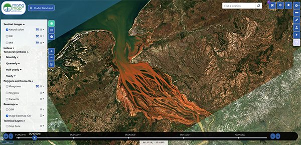
For each of the sites offered by the platform, MangMap uses the repeatability and spatial resolution of the 2 Sentinel 2 satellites to provide 10 m resolution products that have been updated on average every 5 days since 2016. The platform exploits the 13 spectral bands of the data, including the near-infrared, to calculate standardised indices relating to vegetation, soil and water. The mid-infrared band of the least cloudy image acquired during the current quarter is used to calculate a quarterly mask of the spatial distribution of mangroves present on the site. Mangmap can use digital surface models derived from remote sensing, distributed by ESA or NASA (SRTM type).
Future versions of the MangMap platform will incorporate Mangrove products derived from Very High Spatial Resolution (VHSR) imagery processing, which complement Sentinel 2 high-resolution data thanks to the level of detail they offer. The UMR Espace-dev team is carrying out experiments in this area for certain MangMap pilot sites, in partnership with the DINAMIS facility and as part of CNES-TOSCA R&D projects. The feasibility of using time series of radar imagery from the Sentinel1 constellation to offer new Mangrove products is also being analysed within MangMap.
IT infrastructure
The MangMap platform in production is installed in the hardware infrastructure of UMR Espace-dev (IRD component), hosted at the Centre Informatique National de l'Enseignement Supérieur (CINES) in Montpellier.
This infrastructure is a component of the Montpellier Data and Services Centre (CDS), which the Espace-dev and Tetis Research Units based at the Maison de la Télédétection in Montpellier have deployed within the collaborative frameworks set up and run by the Theia cluster and the Data Terra national infrastructure.
External Complementary Resources
The conservation and sustainable management of mangroves require access to accurate and up-to-date data on their status, evolution, and geographical distribution. To complement MangMap's technical resources, we have selected ten reference platforms that offer complementary tools and data for mapping and monitoring mangroves. Each resource presents unique characteristics and can be used in synergy with the services offered by MangMap.
A global reference site that stands out for its clear and intuitive cartographic interface, providing access to detailed maps based on remote sensing. The platform mainly uses data from NASA's EarthData and offers the possibility of conducting in-depth temporal analyses. However, the integration of new data can take time, and searching for specific information sometimes requires extensive navigation. Users will note that the sources of the data are not always clearly indicated in the interface.
NASA EARTHDATA Portal - Mangroves Section
The official NASA portal that serves as the primary data source for many other mangrove monitoring platforms. This resource stands out for its free, regularly updated data and the scientific rigor of its publications. However, the portal has a major limitation: the absence of a dedicated cartographic interface, which can complicate the direct use of data for some users.
The Ramsar Sites Information Service (RSIS)
A global database that comprehensively inventories wetlands, including mangroves. Its strength lies in the precision of its geolocated data and its particular emphasis on conservation actions. The site's interface would benefit from modernization to facilitate navigation, and some historical data would gain from being updated more regularly to maintain the relevance of the information provided.
This reference platform effectively centralizes global cartographic data on mangrove restoration, notably integrating GMW data. Its recent migration to ArcGIS offers advanced functionalities but may present a learning challenge for new users unfamiliar with this technology.
[Link to Global Mangrove Alliance website] An international collaborative initiative launched in 2018 that excels in networking actors and accessing funding for mangrove conservation. Although not primarily a cartographic resource, the platform plays a crucial role in centralizing global initiatives and supporting conservation projects.
Blue Ventures - Google Earth Engine Mangrove Mapping
An innovative mangrove mapping tool developed on the Google Earth Engine platform. Its strength lies in its global accessibility and open-source nature. However, using this tool requires technical skills in Google Earth Engine and Git, and the results produced need rigorous validation to ensure their reliability.
World Resources Institute (WRI) - Global Forest Watch
A reference cartographic platform that stands out for its optimized interface and efficient aggregation of multiple sources of forest data. Regular updates and the integration of data from GMW, EARTHDATA, and UNEP-WCMC make it a particularly comprehensive tool. The wealth of available information, which goes beyond the scope of mangroves alone, may require some expertise to efficiently navigate to specific data being sought.
Conservation International - Mangrove Restoration
A dynamic platform dedicated to conservation and restoration projects, distinguished by the quality of its educational resources and its rigorous system for measuring project impact. Although not offering interactive mapping, the site provides regular news and valuable information on conservation initiatives, despite navigation that could be simplified.
A reference organization in the field of wetlands, particularly recognized for its flagship program Mangrove Capital Africa. Its technical expertise and concrete field projects make it an essential resource, even if its geographical focus is currently concentrated on Africa, thus limiting the global scope of its interventions.
To complement these major platforms, we have also identified several resources, particularly French-language ones, that deserve your attention:
- National Network for Observation and Management of Mangroves (ROM) and Tropical Wetlands Resource Center
- Cartography of the spatiotemporal evolution of mangroves in Benin and projection of their future state by 2050
- National mangrove areas subject to conservation measures (referring to the CARNAMA project)
- New mapping of French mangroves
- French Global Environment Facility: Mangrove Initiative
- Mayotte Marine Park: Mangrove Monitoring (Bluecham)
- Classifying mangroves using DeepLearning algorithms
- Mangrove & Macrobenthos/Management Meetings
- Ocean Wealth